
Raymond J. Pool, Field Notes, 1912, Part 2
Field Notes, 1912
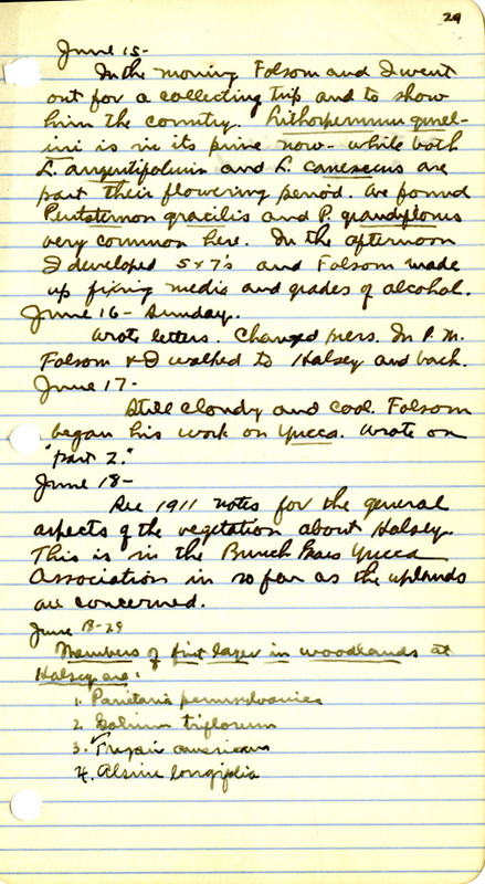
29
- Parietaria pensylvanica
- Galium triflorum
- Fragaria americana
- Alsine longifolia
20. Elymus stricta
21. Oryzopsis micrantha
30
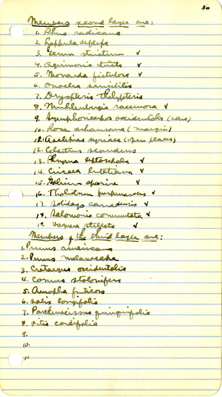
Members second layer are:
- Rhus radicans
- Lappula deflexa
- Geum strictum
- Agrimonia striata
- Monarda fistulosa
- Onoclea sensibilis
- Dryopteris thelypteris
- Muhlenbergia racemosa
- Symphoricarpos occidentalis
- Rosa arkansana (margin)
- Asclepias syriaca
- Celastrus scandens
- Phryma leptostachya
- Circaea lutetiana
- Galium aparine
- Tholitnen pupurascens
- Solidago canadensis
- Salomonia cobrensis
- Vagnera stellata
Members of the third layer are:
- Prunus americana
- Prunus melanocarpa
- Crataegus occidentalis
- Cornus stolonifera
- Amorpha fruticosa
- Salix longifolia
- Parthenocissus quinquefolia
- Vitis cordifolia
31
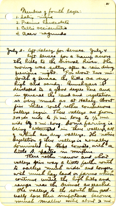
Members of fourth layer:
- Salix nigra
- Fraxinus lanceolata
- Celtis occidentalis
- Acer negundo
July 3 — Left Halsey for Seneca. July 4 left Seneca for a tramp across the hills to the Dismal River. The morning was sultry after a rain during previous night. For about two mi. south of Seneca the hills are very high and sandy. Bunch grass is develeped to a good degree here and in general the land and vegetation is very much as at Halsey. About five miles south rather conspicuous valleys begin. These valleys are from 300 yds. wide to 1/2 mi. long to 1/2 mi. wide by 2 mi. long. Some farming is being attempted in these valleys, all of which are dry valleys. The native vegetation of these valleys is usuallly dominated by Stipa Comata, with a little S. spartes in mixture.
These rather narrow and short valleys give way a little farther south to valleys much wider and longer with much hay land or farms which contiunue until the high hills and ranges near the Dismal are reached. The valleys to the south then gradually lose their importance become much smaller until about 2 mi.
32
from the Dismal Valleys disappear entirely and the very high hills on the Dismal are much like those on the Middle Loup at Seneca.
This narrow valley strip marks the eastern limit of dry valleys in the southern hills. East of of a line drawn from Seneca to the Dismal Valleys of ever small size quickly give way to choppy hills. While westward of the same hills the valleys rapidly broaden out until the broad wet valleys of McPherson and Grant Counties are reached. From this point westward the valleys again become smaller and less numerous as one passes into Garden and Morrill counties.
The vegetation on the Dismal south of Seneca is practically the same as at Black’s Ranch farther east. In numerous place here Fraxinus lanceolata is seen climbing the steep south slopes from near the water’s edge and appear to be spreading to a considerable degree. Considerable Lepargyrea argentea and Juniperus scopulorum was seen at this point. The hills on both sides of the river at this point are very high averageing about 300 ft.
We passed through some sheep pasture where the range was suffering very greatly from these animals. The grains and all herbiage was
33
being cropped and tramped to very dangerous degree. The animals were very “measley” looking — about 1000 head of ewes & rams & 300 lambs.
I saw some fields that had been broken out about 7 mi. south of Seneca that were in a deplorable condition. They were in good level valleys with good soil for alfalfa but had been allowed to go to weeds to a frightful degree. Helianthus petiolaris and H. annuus controlled practically all such fields some of which contained as much as 60 a. If fields are allowed to stand idle here, i.e. if not used for crops, They should at least be surface cultivated to keep down weeds and to conserve or “store” water for succeding crops. All such fields would produce fine crops of alfalfa or timothy.
34
From Crawford northward from Pine Ridge one soon comes to the [Buce?] Clay formation with its characteristic erosion figures and Bad Lands. There extends alon g the north face of Pine Ridge for many miles from the Wyoming line in Nebraska. They extend from the base of the Ridge for an average of 6-10 mi. northward. In some places they are very rough, deep and barer. While in others they are little more than patches of outcropping clay which here and there some rock in mixture.
In some places the whole region is no more than a mile across from south to north while in others it is several miles. Here and there great knobs or points of clay stand out as isolated points over the generally rolling landscape. Some such points are 100 — 150 ft. in height and absolutely bare of vegetation. there are two quite distinct clays here: one a light green which is least common, and the other a red or flesh colored clay which is much the more common type. The green clay is in some places beneath the red clay. The two contain much rock, quartz and fossils.
35
July 6
Bad Lands Plants 1912
- Sideranthus grindelioides
- Pachylophis caespitosus
- Arenaria hookeri
- Leucelene ericoides
- Artemisia cana
- Allium reticulatum
- Kuhnistera purpurea
- Kuhnsitera candida
- Paronychia jamesii
- Agropyron dasystachum
- Opuntia polyacantha
- Cymopterus montanus
- Sitanion elymoides
- Eriogonum multiceps
- Malvastrum coecineum
- Prosalea floribunda
- Linum rigidum
- Calochortus gunnisonii
- Koeleria cristata
- Artemisia tridentata
- Eriocoma cuspidata
- Bulbilis dactyloides
- Bouteloua oligostachya
- Atheropogon curtipendula
- Carex filiformis
- Helianthus petiolaris
- Stipa viridula
- Stipa Comata
- Oreocarya suffruticosa
- Mentzelia decapetala
- Tropimon cuspidatum
- Artemisia frigida
- Chenopodium album
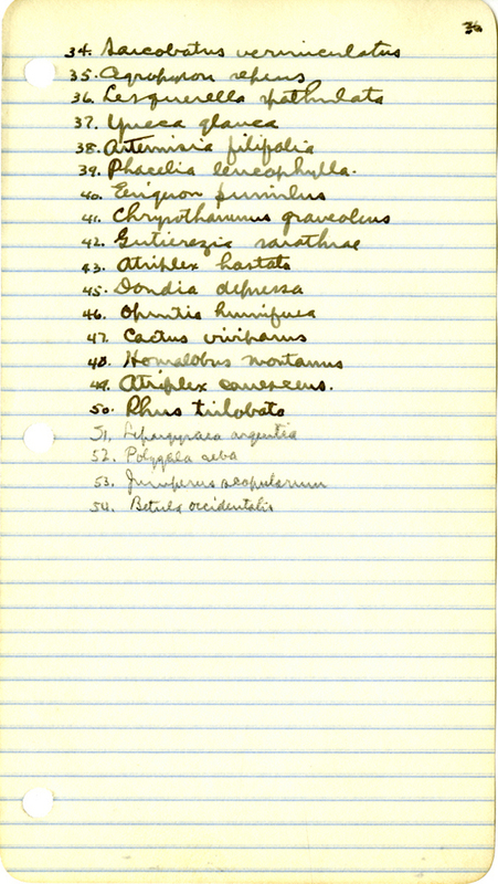
36
34. Sarcobatus vermiculatus
35. Agropyron repens
36. Lesquerella spatulata
37. Yucca glauca
38. Artemisia filifolia
39. Phacelia leucophylla
40. Erigeron pumilus
41. Chrysothamnus graveolens
42. Gutierrezia sarothrae
43. Atriplex hastata
45. Dondia depressa
46. Opuntia humifusa
47. Cactus viviparus
48. Homalobus montanus
49. Atriplex canescens
50. Rhus trilobata
51. Lepargyrea argentea
52. Polygala alba
53. Juniperus scopulorum
54. Betula occidentalis
37
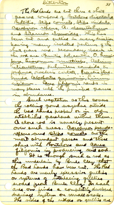
Distribution
The Bad Lands are cut thru a grass sod composed of Bouteloua oligostachya, Bulbilis, Stipa comata, Stipa viridula, Agropyron repens, A. dasystachyum, and Sitanion elymoides. This has been cut and gullied in every direction leaving many isolated pastures of the short grass sod. Secondary species in the sod are Opuntia polyacantha, O. humifusa, Eriogonum multiceps, Allium reticulatum, Kuhnsitera candida, K. purpurea, Koeleria cristata, Psoralea floribunda, Calochortus gunnisonii, Linum rigidum. Carex filifolia random in many place the the principal grasses in abundance.
Such vegetation as this covers the rolling ground everywhere outside the bad lands proper or in old established grassland within them. A close sod is usually present over such areas. Agropyron pseudorepens and Stipa comata are the most abundant grasses and there share with Bouteloua and Carex filformis in producing said sod.
It is through such a sod as this underlain by Bank Clay that the Bad Lands have been cut. The Bad Lands are merely excessive gullies eroded from Bank clay. In each area one finds a completely developed drainage system of small scale. The sides of the ridges or gullies are
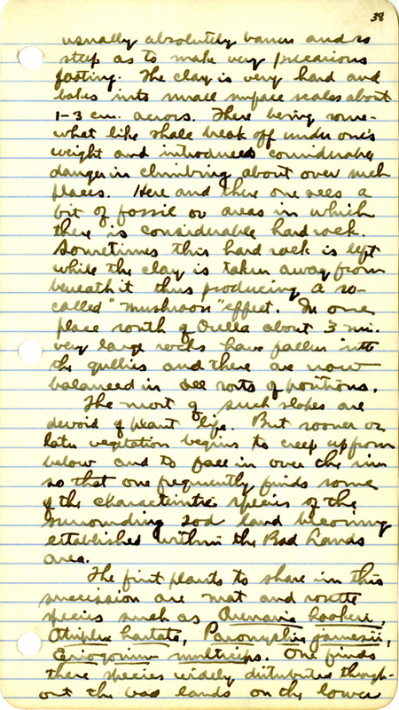
38
usually absolutely barren and is steep as to make very precarious footing. The clay is very hard and takes into small surface scales about 1-3 cm. across. There being somewhat like shale break off under ones weight and introduced considerable danger in climbing about over such places. Here and there one sees a bit of fossil or areas in which there is considerable hard rock. Sometimes this hard rock is left while the clay is taken away from beneath it thus producing a so—called “mushroom” effect. In one place south of Ocella about 3 mi. very large rocks have fallen into the gullies and there are now balanced in all sorts of positions.
The most of such slopes are devoid of plant life. But sooner or later vegetation begins to creep up from below and to fall in over the rim so that one frequently finds some of the characteristic species of the surrounding sod land becoming established with the Bad Lands area.
The first plants to share in the succession are mat and rosette species such as Arenaria hookeri, Atriplex hastata, Paronychia jamesii, Eriogonum multiceps. One finds there species widely distributed throughout the bad lands on the lower
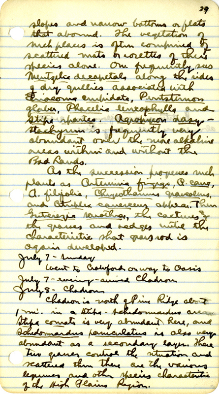
39
slopes and narrow bottoms or flats that abound. The vegetation of such places is often comprised of scattered mats or rosettes of these species alone. One frequently sees Mentzelia decapetala along the sides of dry gullies associated with Eriocoma cuspidata, Penstemon glaber, Phacelia leucophylla, and Stipa spartes. Agropyron dasystachyum is frequently very abundant over the more alkaline areas within and without the Bad Lands.
As the succesion progressese such plants as Artemisia frigida, A. cana, A. filifolia, Chrysothamnus graveolens, and Atriplex canescens appear. Then Gutierrezia sarothrae, the cactuses and the grasses and sedges until the characteristic short grass sod is again developed.
July 7 — evening — arrived Chadron
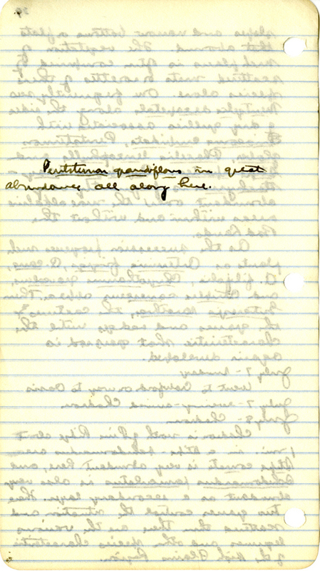
Penstemon grandiflorus in great abundance all along here.
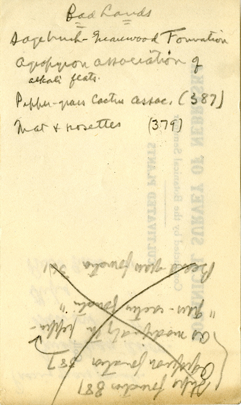
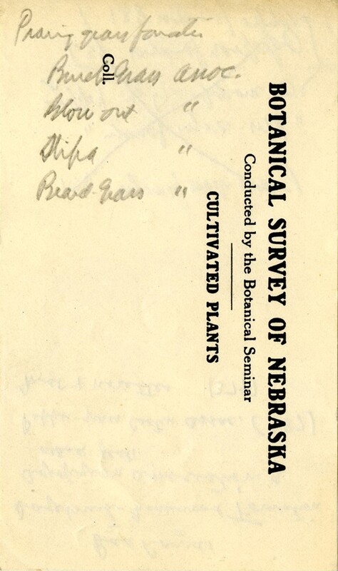
Prarie gras formation
Buch Grass assoc.
Blow out ”
Stipa ”
Beard ”
40
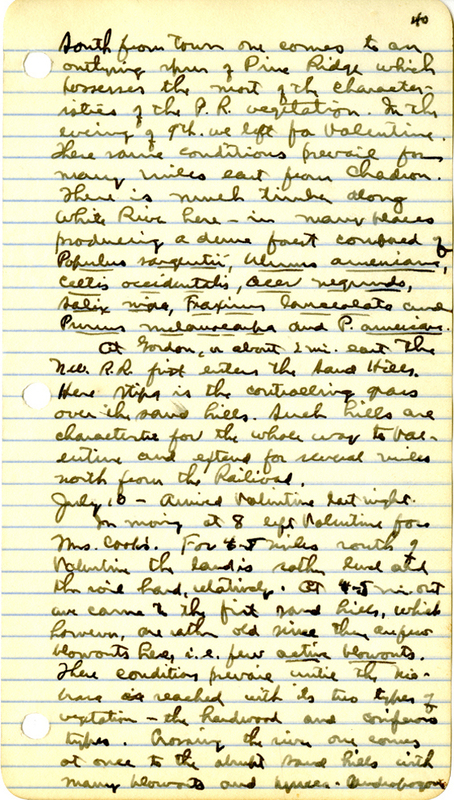
South from town one comes to an outlying spur of Pine Ridge which posseses the most of the characteristics of the P.R. vegetation. in the evening of the 9th we left for Valentine. These same conditions prevail for many miles east from Chadron. There is much timber along White River here — in many places producing a dune forest composed of Populus sargentii, Ulmus americana, Celtis occidentalis, Acer negundo, Salix nigra, Fraxinus lanceolata, and Prunus melanocarpa, and P. americana.
At Gordon, about 2 mi. east the new R.R. first enters the Sand Hills. Here Stipa is the controlling grass over the Sand Hills. Such hills are characteristic for the whole way to Valentine and extends for several miles north from the Railroad.
July 10 — Arrived Valentine last night.
In morning at 8 left Valentine for Mrs. Cook’s. For 4 – 5 miles south of Valentine the land is rather level and the soil, relatively. At 4 — 5 mi. out we came to the first sand hills, which however, are rather old since they are few blowouts here, i.e. few active blowouts. There conditions prevail until the Niobrara is reached with its two types of vegetation — the hardwood and coniferous types. Crossing the river one comes at once to the abrupt sand hills with many blowouts and Yucca — Andropogon
41
The hills immediately south of the river are very high and steep. The Pinus ponderosa and less noticeably the hardwoods follow the Gordon Canyon and simliar spring trenches, tributaries to the Niobrara, for many miles into the hills. The Gordon carries pines for at least 8 mil. into the hills from the Niobrara. With this arborescent vegetation then follows many of the species of high plains and Pine Ridge plants.
Arrived at Mrs. Cooks at 2 p.m. Had dinner then Folsom and I went out on Hackberry Lake for a couple of hours. Potamogeton richardsonii, P. pectinatus, P. zosterifolius, P. natans, and P. lonchites, Ceratophyllum demersum, Batrachium dwanicatum and Myriophyllum spicatum were abundant, as were also Lemna trisulca which was beginning to come to the surface
July 11
42
July 11
Went out southeast between Dewey and Clear lakes then came back home via north shore of Clear. On the divide between there two ladies the are high and there are numerous blown outs in various stages of being reclaimed. There are no active blows here however, i.e. blowouts into which plants have not yet obtained a start. this area has been heavily grazed so the Muhlenbergia pungens, and Redfieldia are everywhere common and the sand shows at short intervals. There is no Ceanothus ovatus here at all, and Prunus besseyiis only moderately common. Yucca glauca is very abundant, so that with Muhlenberigia the formation here has a little stronger relation to the Yucca-Muhlenbergia association than to the Yucca-Andropogon association though this relation various on the different hills.
On the north shore of Clear Lake wear the east end there are a number of large “cattle runs” that are very rugged and bare. There have been blown out from the beach to several hundered feet back in
43
somes cases. Redfieldia is begining to cover some of the slopes of these incipient sand draws and Psoralea lanceolata is also coming in in many places. Most of the swampy area about Clear Lake is at the east end, tho the lake as a whole is quite freom from Rushes or aquatic vegetation.
In the afternoon I went out on Hackberry Lake and made a number of hygrometric determinations which are found on another page.
July 12 —
Went to falls on Snake River about 15 mi. N.W. from Mrs. Cooks. All the way over we traveled by way of the hay meadows. the hills are of average height but are much better covered by vegetation than those in Thomas Co. or in eastern Cherry Co. There were very few blowouts seen on the way — even the older ones were scarce and were well covered. The valley of the Snake is lined by very high hills especially on the north and west side. These hills are about 400 ft. about the river level. On the east side there is extensive river flat vegetation upon a clayey soil with Bouteloua predominating. Considerable

44
Andropogon scoparius has come down from the hills and has become established on the flats. No Ceanothus was seen on the way.
The gorge of the Snake at and below the falls is very precipitous and rocky. The river has cut through the hills and the Arikarce formation to a depth of about 400 ft. The sides of the hills on the upper slopes and the outercropping rocke covered by the typical Pine Ridge vegetation of Pinus ponderosa comprises the bulk of the first layer. Some of these trees are very large and stocky. Mixed with the pine Juniperus scopulorum is quite frequent also as very well developed trees some of them 40 ft. in height. The upper stretches of the canyon show such shrubs as Rhus trilobata, Ribes aureum, R. floridum in abundance. As one descends into the gorge the deciduous trees become commoner until in the bottom this belt is very well developed. The tree that are common are Populus sargentii, Ulmus americana, U. racemosa, Celtis occidentalis, and the two prunis P. americana and P. melanocarpa. The first three species occur as very large individuals while the last ones form the characteristic
45
thicket type of vegetation. Parthenocissus quinquefolia, and Vitis cordifolia, Clematis ligusticifolia, and Celastrus scandens are common liamas that cover the low trees and shrubbery with a dense cover of tangled wire — like stems. Rhus trilobata occupies rocky areas by the characteristic colonies of 4 — 10 ft. in diameter. Rhus glabra is abundant on the upper slopes where it exists in the usual thicket association with grasses beneath. Campanula petiolata, Amelanchier alnifolia, Arenaria hookeri, Paronychia jamesii and Orophaca cespitosa one other common Pine Ridge species that were common.
Toward the valley of the Sanake and on the lower slopes of the hills on each side of the canyon the Stipa comata association is very conspicuous. This grass covers wide stretches of blow out, less hills back from both sides of the river and sharing the uplands with Andropogon scoparius. There is little Yucca glauca here and not Muhlenbergia purpens was seen anywhere on the uplands. The hills here then are relatively old as compared with those farther east and south.
46
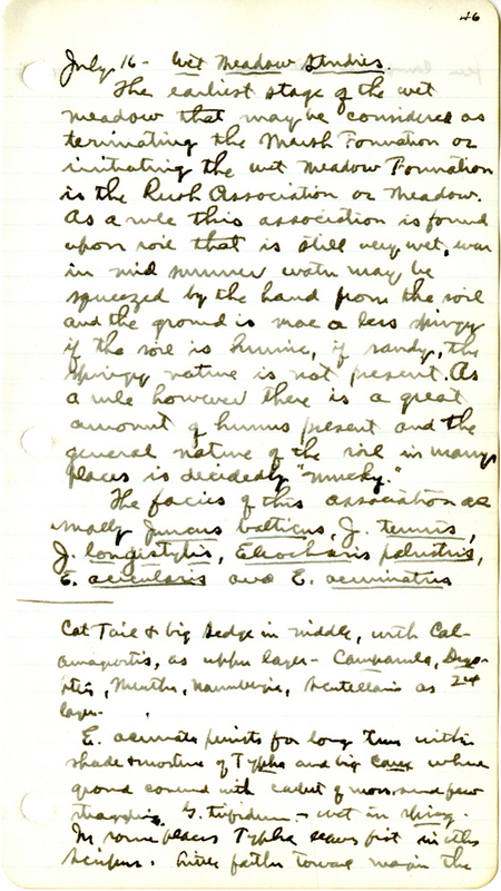
July 16 — Wet Meadow Studies
The earlist stage of the wet meadow that may be considered as terminating the Marsh Formation or imitating the Wet Meadow Foundation in the Rush Assocication or Meadow. As a rule this association is found upon soil that is still way wet, was in mid summer water may be squeezed by the hand from the soil and the ground is more or less springy if the soil is humic, if sandy, the springy nature is not present. As a rule however there is a great amount of humus present and the general nature of the soil in many places is decidedly “mucky.”
The facies of this association as usually Juncus balticus, J. tenuis, J. longistylis, Eleocharis palustris, E. acicularis, and E. acuminata.
Cat Tail & big Sedge in middle, with Calamagrostis, as upper layer — Campanula, Dryopteris, Mentha, Nanubergia, Scutellaria as 24 layer.
E. acuminata persist for long time within shade & moisture of Typha and big Carex where ground covered with carpet of moss and few straggling G. trifidum — wet in Spring. In some places Typha occurs first in with Scirpus. Little farther toward W. in the
fern Campanula belt begin.
47
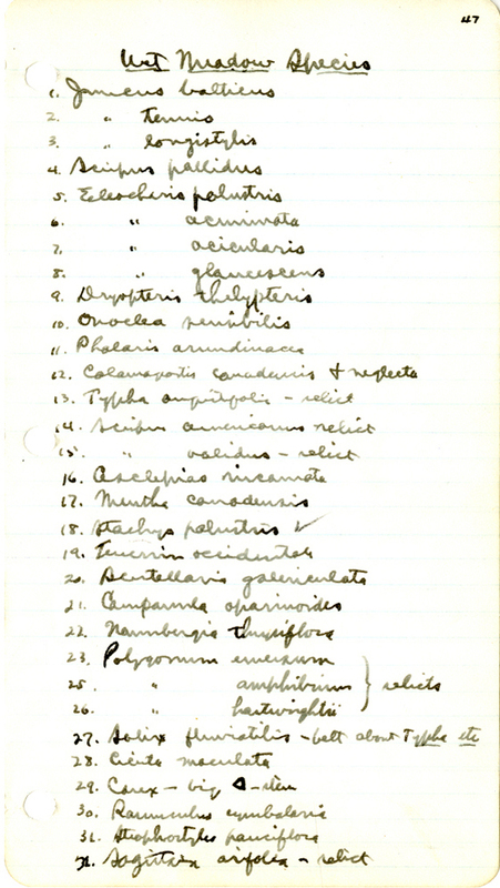
Wet Meadow Species
- Juncus balticus
- ” tenuis
- ” longistylis
- Scirpus pallidus
- Eleocharis palustris
- ” acuminata
- ” acicularis
- ” glaucescens
- Dryopteris Thelypteris
- Ovoclea sensibilis
- Phalaris arundinacea
- Calamagrostis canadensis & neglecta
- Typha angustifolia — relict
- Scirpus americanus relict
- ” validus — relict
- Asclepias incarnata
- Mentha canadensis
- Stachys palustris
- Teucrium occidentale
- Scutellaria galericulata
- Campanula aparinoides
- Naumburgia thyrsiflora
- Polygonum emaciatum (relicts)
- ” amphibium (relicts)
- ” hartwrightii (relicts)
- Salix fluviatilis — belt about Typha etc.
- Cicuta maculata
- Carex — big — stem
- Ranunculus cymbalaria
- Strophostyles pauciflora
- Sagittaria arifolia —relict

48
32. Rumex britannica (relict)
33. Rumex hydropiperoides
34. Cythenus datum (in ferns)
35. Helianthus tuberosus (on margins)
36. Steironema ciliatum
37. Galium trifidum
49
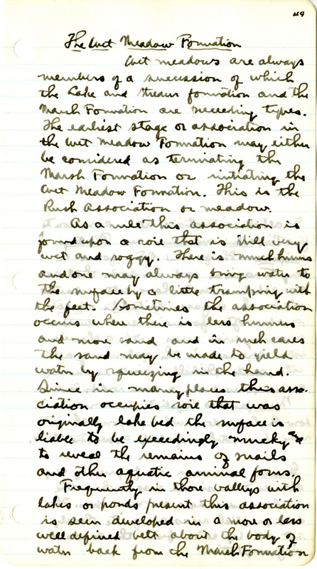
The Wet Meadow Formation
Wet meadows are always members of a succession of which the Lake and stream formation and the Marsh Formation are preceeding types. The earliest stage of association in Wet Meadow Formation may either be considered as terminating the Marsh Formation. This is the Rush Association or meadow.
As a rule this assoication is found upon a soil that is still very wet and soggy. There is much humus and one may always bring water to the surface by a little tramping with the feet. Sometimes the association occurs where there is less humus and more sand and is such cases the sand may be made to yield water by squeezing in the hand. Since in may places this association occupies soil that was originally lake bed the surface is liable to be exceedingly mucky and to reveal the remains of snails and other aquatic animal forms.
Frequently in those valleys with lakes or ponds present this association is seen developed in a more or less well defined belt about the body of water back from the Marsh Formation.
In alkali situations it is common to find Triglochin maritima and Plantago eriopoda. The former often froms a very tenacious sod in soils that are so alkaline as to have salts separated out on the surface. Distichlis spicata is also often found in such situations covering wide areas with a characteristic close sod to the exclusion of all other plants. Distichlis spicata is also very commonly present in a dune — soddy layer.
Menyanthes trifoliata is common in low Rush meadows where it forms characteristic low patches of closely aggregate plants.
Gerardia besseyana is frequently very abundant in small areas where the rushes and sedges are more open. The dark purplish areas are quite clearly set out by color form the surrounding vegetation.
50
In meadows from which surface water has disappeared the assoiciation is more diffuse or irregular and often alternates in the wetter portions with the other associations of the formation.
The species that give character to this association are Juncus balticus, J. tennis, J. longistylis, J. nodosus, Eleocharis palustris, E. acicularis, E. acuminata, and Scirpus atrovirens, and S. americanus as relicts from the Marsh Formation. Scirpus validus also often persists for a number of years as a relict. So also Typha latifolia remains as a few widely scattered slumps or individual plants until the soil has become quite dry. From the fact that the association becomes very wet and seems very much during the spring months one readily sees why these common relicts are able to persist. The surface of such places is very often cover by water that does not
disappear in some cases until mid-summer.
The presence of te Junci and Eleochari in close aggregation is to be considered as the typical expression of this association. In such habitats as outlined above there together or in pure stands frequently cover
The dense thickets of Willow — probably S. fluviatilis, belong either in th Rush or Fern meadow associations. Extensions areas composed of round topped topped bushes about 8 ft. in height are very common in the wet meadow region. There are to be seen in best development just southside the March Foundation and occupying ground very similar to that of the Rush or Fern associations. In fact the willow very often have the appearance of islands or tongues scatterd over both of there associations. The willows produced a deep shade within which the Ferns are most abundant of the meadows species although, Campanula aparinoides, Galium triflorum, and a few other species are formed there in greatly modified forms. Amorpha fruticosa is present in small quatities in there willow patches. There shrubby mosses often exist as a perfect belt about the Rush — Typha — Phragmites combination.
Caltha palustris abundant in many wet meadows.
51
The ground with a close sod. Eleocharis palustris is often seen in such close stands as to completely dominate wide stretches and to keep out practically every other plant. Occasionally one finds a cleanup of Pamenlaris ameica or Catabrosa aquatica in such places, or the stems of some of the above named relicts. But where the association is more open the flora is more varied. A common type of distribution is to have a rather thru cover E. palustris with an almost equal mixture of the Junci, and from this the relation varies in both directions. Sometimes on the sandy shores of lakes and ponds throughout the region a perfect carpet of E. acuminata or E. acicularis is developed just outside the water live in which may occur scattered colums of Scripi and Junci. There carpets are especially noticebly about the Cherry Co. lakes. It is here also that the carpets of Halerpestes cymbalaria cover the wet sand for many square meters. These patches are especially striking when the plants are in bloom.
In the outer or or drier potrtions of the association such plants as Lycopus lucidus, L. americanus, Mentha canadensis, Lythrum alatrum, Steironema
Spirodela polyrrhiza in colonies on wet sand midst rushes.
Sometimes the associations of this formation are so telescoped that the identity of the various assoication is all or very nearly lost.
52
ciliatum, Potentilla paradoxa, P. monspeliensis, Scutellaria glabriuscula, Lotus americanus, Naumburgia thyrsiflora, and Rumex Hydropiperoides, are more or less frequent and abundant. Some of these often form extensive patches through this and the following association.
The Fern Meadow Association
In the regular succession backward from the shore the one association that is most widespread and typical is the fern meadow. This is usually occupies rich soil which has been badly broken up by cattle and horses coming down to water until there arem innumerable depressions in elevation with a differences in elevation of about 2 ft. ofcourse in many places not open to the stak the ground is much more smooth. The soil is always higher and dries than in the last association and is better drained.
Color is given to there areas by the presence of two ferns, Dryopteris thelypteris and Onoclea sensibilis. The former is much the more frequent and abundant throughout the wet
53
meadow lands of the region. Often there ferns, especially the former, are developed to the degree that alomst everything else is excluded from the area of ferns — sometimes a few plants of Calamagrostis canadensis or others. Dryopteris is rarely seen within th eshade of deeper associations but Onoclea is a frequent members of shaded habitats. In thy extensive wet meadow of Cherry Co. These areas dominated by the ferns are often more or leass notted by the presence of patches of accessory species that dominat their own particular patches: Campanula aparinoides frequently occurs as a layer from this association well into the hay meadow and covers hundreds of square meters with its tangel of sprawling stems; the source is true in less degree for Galium trifidum, Naumburgia thyrsiflora, Crepis runcinata, and Asclepias incarnata, and many species that are probably members of the following association.
54
The Hay Meadow Association
In the most of the many extensive and broad valleys of the northern portion of the Sand Hill Region, even with those that still show ponds or lakes, there is usually a wide expanse of drier land coverd by grasses and associated plants that are cut for hay the owners. In the broader valleys this type of vegetation covers by far the most of the land. * The soil as a rule is hard and smooth and provided with a good water supply river it is only a few feet above the water table. I have chose to call this the Hay Meadow Association from its very obvious economic importance. This association is included in the Wet Meadow Formation of Pound and Clements but is not treated to any degree by these authors. The association gives way in the drier situations in wet valleys and in the dry valleys outside the wet valley region to the dry valley or pocket association which very soon then becomse the Bunch Grass association>
The species that give color to this association are in the main grasses. These are many hundreds of acres of
Agropyron smithii common
Panicum implicatum forms low hairy carpets in more open areas.
Spartina cynosuroides as scattered tall stems in low places. Eatonia obtusata is very common and of valuabel grasses of the drier situations.
Bromus ciliatus common on the highest land in there valley there is considerable Stipa comata, but here the grass is much thinner and the vegetation is more of the dry valley or high plains type.
55
this sort of vegetation within the wet valley region. The soil sandy loam is firm and soddy and is provided with a considerable supply of humus. The species that are of widest distribution in such areas are: Agrostis alba, A. hyemalis, Agropyron repens, A. tenerum, Calamagrostis canadensis, C. neglecta, Panicum virgatum, Elymus canadensis, Beckmannia eruciformis, Equisetum variegatum, Koeleria cristata, Andropogon provincialis, and Muhlenbergia racemosa. In some places certain of there are more abundant than others, for instance the Agropyrons are liable to be found in greater abundance on the higher and dryer areas while Elyrum is to be found usually in the lower areas. But typically the grasses are so mixed that no alteration of species can be discovered at all.
Hordeum jubatum another very frequent and abundant species. This species is often seen as a belt about ponds or wet depressions. Agrostis hyemalis is also often seen in a finely developed belt of 10-60 ft broad about lakes and ponds just back of the Rush association. Sometimes this association joins directly upon the various aspects of the Marsh Foundation
Rudbeckia is usually on lower ground than Ratibida — they were frequently show this kind of zonation about low places
56
where the Rush assoiciation or the Fern association are lacking. Where the soil transistion is sudden one often finds the hay meadow joining directly the hay meadow joining directly the Sagittaria, Phragmites or Scirpus combination. More usual however there tow types are separated by a belt of Polygonnum hartswrightii, or as typical the Rush Association tho this may be but a narrow belt.
There are many secondary species to be found in the these meadows. Besides a few relicts such as Scirpus americanus and S. validus, Typha latifolia etc. from former associatioin the following species of the hay meadows. Those that from conspicuous patches, that might perhaps be given the name society, are Cicuta occidentalis which is frequently of controlling abundance over the wide stretches in the lower situation of the association during the month of July. Then also Naumburgia thyrsiflora, Mentha canadensis, and Stachys palustris are very frequent and often abundant in swales so as to be locally very conspicuous. On the higher ground Psoralea argophylla forms perhaps the most striking groups of any secondnary species. This plant occurs all the way from scattered individuals to compact patches several
When such a meadow is pastured to a certain degree many of the valuable species are killed out and the secondary species become thirsty emphasized as the soil becomes drier and more open. Such things as Solidago rigida, Euthamia graminifolia, Solidago missouriensis, and were in more seriously trampled areas, Helianthus petiolaris, and Cleome serrulata come in in dense patches. These meadows should be pastured with great care with reference to maintaining a good cover of the valuable species and a proper fencing and notation to keep the stock from the wetter situations at certain seasons in order to prevent the formation of “bogs” with all disagreeable consequences.
57
acres in extent that are noticeable from considerable distances. Ratibida columnaris, and Rudbeckia hirta are two composites that show a decided tendency for aggregation and to cover wide stretches of meadow land with their yellow colors during July. So called Erigeron ramosus bellidiastrum often occurs in rather close stand over wide stretches in the lower portions of the meadows Lotus americanus is found in almost all situations in the meadow but is usually more abundant upon the harder drier soils. In such places the species in sometimes alomst exclusive. In the moister situations, as in swales. The red lily, Lilium umbellatum, becomes gregarious and producer during July one of the most striking patches to be found in any sand hill habitat. Lycopus lucidus and L. americanus often form patches of about the height of the associated grasses. Lobelia spicata is a very frequent inhabitant of other meadows, but the individuals are usually widely scattered. Clusters of Meibomia canadensis are common on lower areas in hay meadows as well as within the Rush and Fern meadow combinations. Habenaria leucophaea is a conspicuous “solitaire” during the month of July. Linum sulcatum
Additional sedges here from 1912:
Scirpus fluviatilis
” pallidus Carex stricta
Eleocharis glaucescens ” scoparia
Carex comosa
” hystericina
” nebrascensis
” marcida
” gravida
” longisortius
” stipata
58
is very frequent, and occassionally becomes sufficiently abundant and aggregated to be conspicuous. Amorpha canescens has wandered in from the hills and is to be found on the elevations then the meadows.
The Stream Side Association
This association differs only slightly frm the Rush and the Fern Meadow associations. The streams of the Sand Hills usually occupy a narrow valley with little or no flood plain. In many places this valley becomes so reduced that only a very narrow canyon persists. The most “canyony” streams of the whole region are Dismal River which rises in a marshy region of Hooker and McPherson Co. and flows eastward to the Loup at Dunning, and the Snake which rises in Sheridan Co. and follows a northeasterly course to Niobrara in norhtern Cherry Co. The Loup rivers, the three of which all arise within the Sand Hill Region should be included in the same series.
This association is to be found in the shady or sandy situations