-
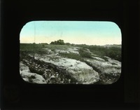
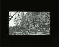
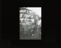
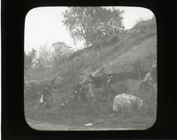 Flint ledge, South Bend
 Original caption: The flint ledge at old quarry opp. So. Bend, Nebr. 1911 Group of men standing at base of flint ledge. Cass County. (121111-00247)
-
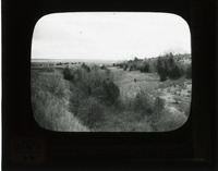
![Original caption: 14-9-09 View in [Yankee Hill Clay pit.] Cullom Gravel. Cass County. (121111-00272)](https://archives-spec.unl.edu/files/medium/bcf507457f8425baf05203681300b68909389827.jpg) Yankee Hill clay pit
Yankee Hill clay pit Original caption: 14-9-09 View in [Yankee Hill Clay pit.] Cullom Gravel. Cass County. (121111-00272)
-
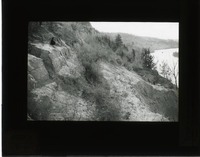
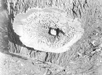
![Original caption: [Drift] Loess Hills, rolling phase, near Plattsmouth, Nebr. 46 L.H. Cass County. (121111-00322)](https://archives-spec.unl.edu/files/medium/e2a458f9de2b0db34b6a9fb7672939260cb0034e.jpg) Loess hills, Plattsmouth
Loess hills, Plattsmouth Original caption: [Drift] Loess Hills, rolling phase, near Plattsmouth, Nebr. 46 L.H. Cass County. (121111-00322)
-
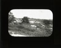
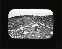 Glacial boulders
 Original caption: Glacial boulders on land so. E. of Table Rock. GEC 1911. Cass County. (121111-00320)
-
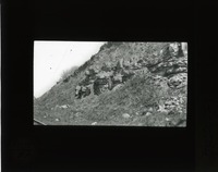
 Limestone, Louisville, South Bend
 Original caption: Louisville & South Bend Limestones. Class studying carboniferous strat. Meadow, Nebr. Cass County. (121111-00245)
-
 Limestone, Missouri River
 Original caption: First l.s. exposed near Mo. R., level north of Weeping Water valley. Looking South. Film XVII-3. N.A.B. 10-12-11 1911. Cass County. (121111-00241)
-
 Limestone, Weeping Water
 Original caption: 9-27-6-11. Limestone blocks, Weeping Water, No. 4. 1911. Cass County. (121111-00240)
-
 Limestone, Weeping Water
 Original caption: 6-27-6-11. Limestone blocks, Weeping Water, No. 3. 1911. Cass County. (121111-00239)
-
 Limestone, Weeping Water
 Original caption: 7-27-?-11. Limestone blocks, Weeping Water. No. 2. Cass County. (121111-00238)
-
 Limestone, Weeping Water
 Original caption: 8-27-6-11. Limestone blocks Weeping Water. No 1. Cass County. (121111-00237)
-
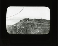
 National Stone quarry
 Original caption: Ledge of National Stone Quarry, east of Louisville. 1911, Cass County. (121111-00236)
-
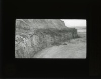
 Limestone, Oreapolis
 Original caption: XXIV-5 NAB. Apr. 19, 1912. Upper l.s. in scarp west of Oreapolis. Part of Plattsmouth l.s. 1912. Cass County. (121111-00235)
-
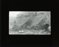
 Cullom ledge, Plattsmouth
 Original caption: NAB. Film XXIV-3 4/3 1912. Shows two upper l.s. in scarp east of Cullom. Upper is 1st above Plattsmouth l.s. Lower is upper part of Plattesmouth l.s. Cass County. (121111-00233)
-
 Limestone, Plattsmouth
 Original caption: XVIII-1 NAB. Apr. 20, 1912. Massive ledge exposed on North side of Platte R. opp. Cullom. The Plattsmouth l.s. NAB 20. Case County. (121111-00231)
-
 LImestone, Cedar Creek
 Original caption: XXVI-4 NAB. Apr. 18, 1912. Massive ledge in n.w. point of bluff, East of Cedar Creek, Nebr., Part of Plattsmouth l.s. Cass County. (121111-00230)
-
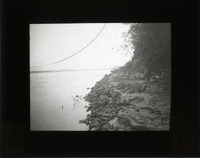
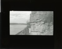
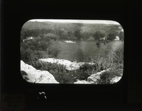
 Limestone, Rock Bluff Point
 Original caption: Lower ledge of l.s. at Rock Bluff Point, so. of Plattsmouth, Nebr. Film XVII 6. 10-13-'11 NAB. Cass County. (121111-00228)
-
 NIobrara landslide
 Original caption: Land slide on Niobrara, N.W. of Ainsworth below mouth of Plum Cr. Brown County. (121111-00055)
-
 Plulm Creek landslide
 Original caption: Landslide below mouth of Plum Cr., N. of Ainsworth, Nebr. Brown County. (121111-00156)
-
 Plum Creek landslide
 Original caption: Landslide below mouth of Plum Creek, N. of Ainsworth, Nebr. Brown County. (121111-00157)
-
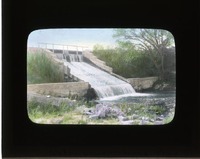 Long Pine spillway
 Original caption: Spillway. water power - Long Pine. Brown County. (121111-00343)
-
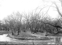 Horseshoe bend, Salt Creek
 Original caption: Salt Creek-Horseshoe bend South of bridge, West of penitentiary. Apr. 20, 1922
-
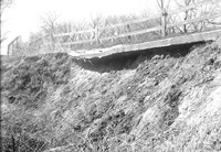 Damaged bridge, Salt Creek
 Original caption: Salt Creek bridge West of penitentiary detail of damaged paving. Apr. 16, 1922
-
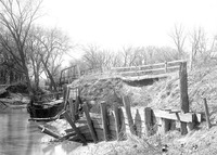 Barricade, Salt Creek
 Original caption: Salt Creek bridge West of penitentiary showing damaged barricade and paving. Apr. 16, 1922
-
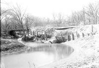 Bridge, Salt Creek
 Original caption: Salt Creek bridge west of penitentiary from south showing bridge and undermined pavement. Apr. 16, 1922
-
 Box elder, Salt Creek
 Original caption: Woodland, North of Salt Lake diseased Box elder-section of trunk.Mar. 3, 1922
